Where Westchester RiverWalk exists in Sleepy Hollow and Tarrytown, it's lovely. At the same time, RiverWalk has limited utility as a transportation facility. The route meanders, with loads of people walking and hanging out on it.
Anyone in Edge-on-Hudson (or eventually, the Manors) aiming to make a train at the Tarrytown station by walking, cycling, etc will realize that taking the streets is the way to pull it off because they offer the most direct route. Unfortunately, these streets are lousy. For people walking, the sidewalks are narrow, sometimes right next to vehicles and/or impeded by utility poles, interrupted by driveways, and on one stretch don't exist at all. To add insult to injury, the walk is dreary, with most of the adjacent properties being industrial, garage doors or blank.
These streets are also uninviting for people who aren't confident cycling. The layout requires people driving to be alert, patient and polite, all of which are in short supply these days.
This document offers solutions that create a safe corridor which will invite people to walk and roll.
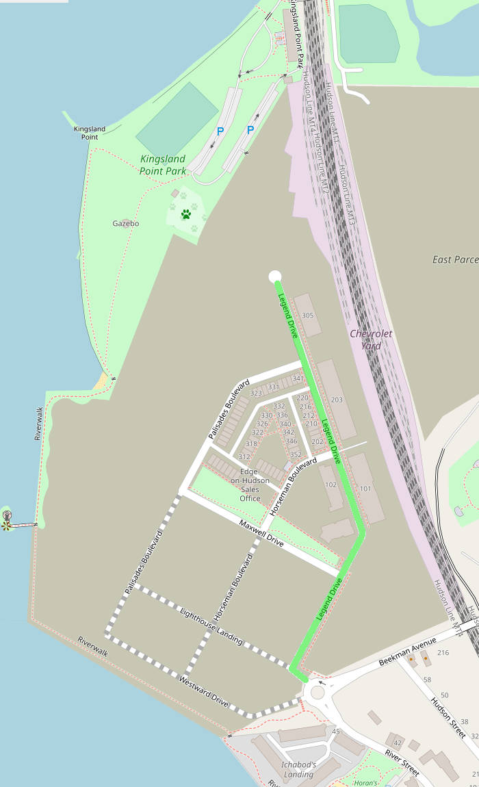
Legend Dr is the main street in Edge-on-Hudson, linking Beekman Ave to the property's northern tip (near Kingsland Point Park's parking lot). (See street highlighted green on the map, right.) It passes several apartment buildings and the spot where the grocery store will be.
This street will be a key north/south cycling route, as it directly links the Manors and the Tarrytown train station area. It needs to be safe for people of all ages and abilities to cycle, scoot and skate on.
Legend Dr is 41' wide, curb to curb, with 13' wide travel lanes and 7.5' parking lanes. Thirteen feet is overly wide, which leads to driving at excessive speeds. For locations like Edge-on-Hudson, the US Department of Transportation's "Flexibility in Highway Design" says it is OK for lanes to be 9' to 10' wide. NACTO's "Urban Street Design Guide" recommends 10' lanes.
The development also has abundant car parking. Each townhome has a 2-car garage (plus most have driveways), the apartment buildings and grocery store have decks or lots, and every street has loads of spots.
Some of that extra lane width and curb space can be reallocated to become protected mobility lanes for cycling, scooting, wheelchairs, etc. Below are two diagrams explaining how to do it.
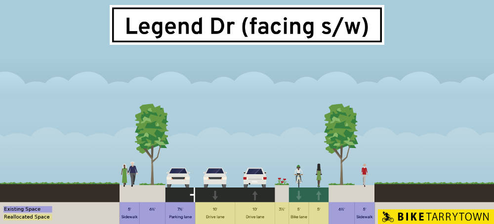
Above is a cross section diagram of our proposal for Legend Dr. From east to west (left to right in this drawing), it contains a 7.5' parking lane, two 10' motor vehicle travel lanes, a 3.5' planted median, and two 5' wide active transportation lanes. Our proposal doesn't change anything outside the curb lines, which on each side are a 6.5' wide planting strip and a 5' sidewalk. (map, view/edit proposal, view/edit existing)
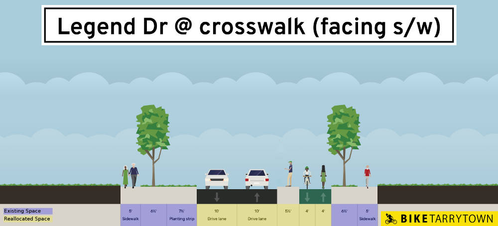
At intersections, the parking lanes currently become curb extensions. The diagram above shows how to handle the 6 locations where the proposed mobility lane meets these curb extensions. It is similar to the prior diagram we discussed, but each of the mobility lanes gets one foot narrower in order to make the planted median a bit wider so it can become a 5.5' wide refuge. This creates an easy to navigate two-stage crossing for people walking. (Note: do not change the curb extensions on the cross streets.) (map, view/edit proposal, view/edit existing)
Further suggestions for making Edge's streets safe can be found in our Director's letter responding to a request from the head of Sleepy Hollow's Building Department.
The first challenge people cycling face is the roundabout at Beekman Ave and River St. It is engineered for quick movement of cars and lacks a dedicated space for people cycling. Making it safer is possible.
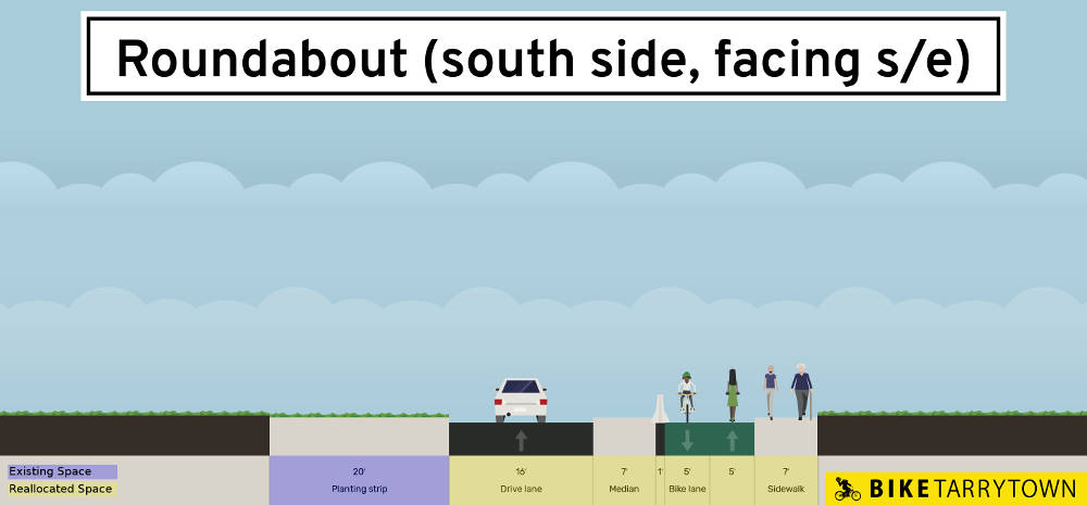
The proposal, above, shows a cross section of the roundabout, along a radius line from the center point to the western edge. The planting area in the middle of the circle remains 20'. (Though engineers may determine part of this needs to become a belgian block apron to facilitate tractor trailer trucks.) The existing inner ring of belgian blocks should be reconstructed into a 16' wide asphalt driving lane. Convert the outer area of the existing asphalt into a 10' wide 2-way protected micromobility lane. Between the two new areas, add a 7' wide cobblestone apron area that can be mounted by trucks needing to navigate the roundabout, plus a wall to keep motor vehicles out of the mobility lane. Widen the sidewalk from 5' to 7' be filling in the planting strip. (map, view/edit proposal, view/edit existing)
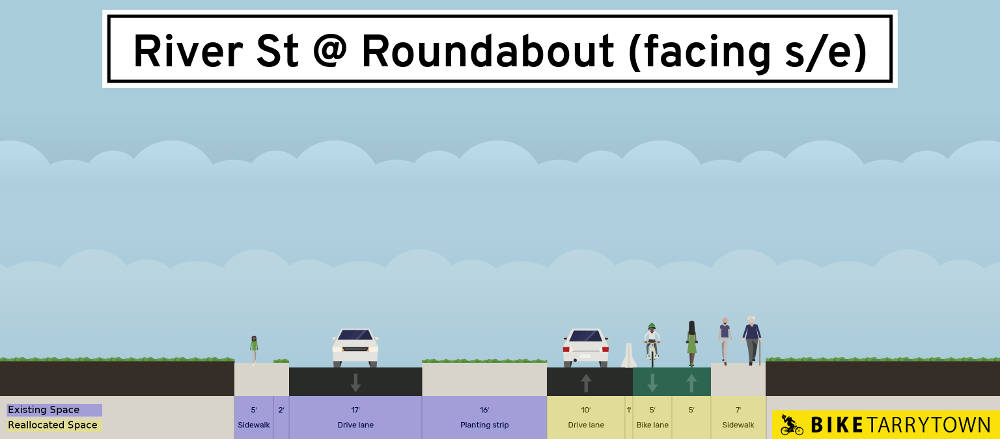
The exit to River St on the south side of the roundabout has a 21' wide driving lane. That car space can be reduced to 10', with the remainder become a 10' wide 2-way mobility lane, plus a 1' barrier to keep truck trailers out. Again, widen the sidewalk from 5' to 7' be filling in the planting strip. Some of the planted median island may need to be converted to belgian blocks in order to enable truck maneuvers. (map, view/edit proposal, view/edit existing)
A bit further south on River St the two driving lanes are 15' wide each. Upgrade that space into a 10' wide 2-way cycling/scooting/etc lane, a 2' buffer and two 9' motor vehicle lanes. (map, view/edit proposal, view/edit existing)
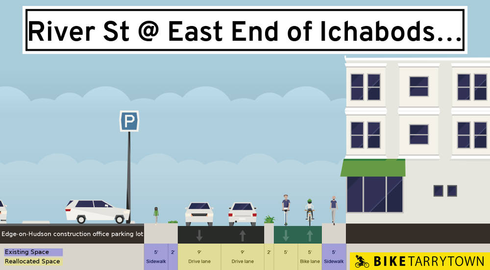
Continuing south, for the block adjacent to River House, narrow the 13' wide motor vehicle lanes to 9' each, then create a 2' buffer and an 11' wide shared path for people walking, cycling, etc. (map, view/edit proposal, view/edit existing)
Traveling on Division St right now is bleak. The southern sidewalk is narrow, jammed between parked cars and the DPW's fence, plus utility poles shrink the walkway's width further, making it impossible to use a wheelchair or stroller. The adjacent land uses are walls, industrial buildings and railroad tracks. The street is a speedway with an overly wide road bed.
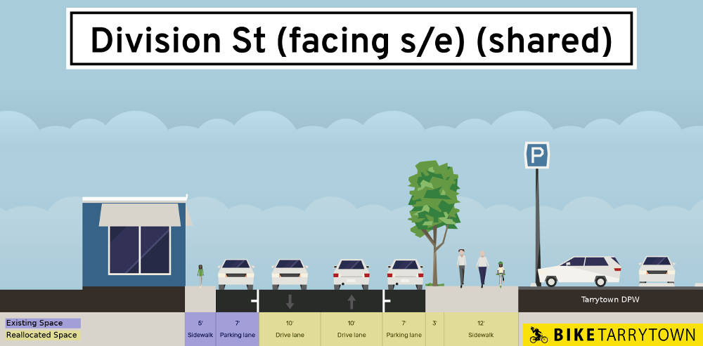
One possible way to make things better within the existing right of way is shown above. It would make the two motor vehicle lanes 10' each and parking lanes 7', adding a 3' planted buffer. Then expanding the southern sidewalk into a 12' wide shared space for walking, cycling, etc. (map, view/edit proposal, view/edit existing)
But this area demands a serious land use transformation. The dead zone created by the Department of Public Works facility on the south side of Division St can be replaced with ground level retail stores with housing above it. The DPW can be moved to the unbuilt section of the Hudson Harbor property, and then have apartments built above it. The value of the retail and residential properties generated would be significant. Tarrytown could leverage that to get Hudson Harbor's developer (Joe Cotter / National Resources) to make this happen.
Transforming the street is then possible by shifting 10' from the DPW property into the public right of way. This allows widening the sidewalks to 7' each, adding 3' of plantings and trees on each side, plus a 10' wide 2-way mobility lane. The motor vehicle portion is two 7' parking lanes and two 10' driving lanes. (map, view/edit proposal, view/edit existing)
Did you know it's possible to travel under the H-Bridge from Division St to Green St? Right now the area contains a jumble of stored trucks and materials. Tarrytown is talking about cleaning up the area, making it a path and gathering space. This would create a direct, level, traffic free route to the train.
This presently dank space can be made lively and safe by updating the zoning to require building storefronts along the path. The Village should also establish leases for temporary or permanent establishments/vendors under the bridge. Bright and decorative lighting should be deployed, as well as security cameras and wayfinding signs.
The southern end of this path connects to Green St where the H Bridge road touches ground. Add a raised crosswalk there so people driving are forced to proceed at a safe speed. Create a 12' wide shared walking/cycling path from the crosswalk to West Main St.
Walking the 200' along Green St from West Main St to the station stairs is so sad -- squeezing along the narrow sidewalk, between car bumpers and the train tracks' chain link fence. (Welcome to Tarrytown!) Fortunately, there is tons of space here which can be used to make this area a gorgeous gateway to the Village.
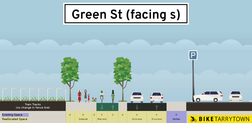
The diagram above shows the train tracks and fence on the left, then we propose making a 4' planting strip with trees, an 8' wide sidewalk, a 2' buffer with plantings, a 10' 2-way mobility lane, a 4' planting strip with trees, then two 9' wide motor vehicle lanes. (The narrow car lanes here are fine because there's no adjacent parking and low speeds are necessary due to the number of people walking here for the parks and trains.) (map, view/edit proposal, view/edit existing)
The existing on road routes go through Hudson Harbor, and they need love and attention. The streets are wider than necessary. One stretch lacks a sidewalk, and where the do exist, they're narrow and disrupted by driveways. Existing buildings have poor street presence. (It's mostly walking by garage doors and blank walls, or walking below an elevated patio of a restaurant set back from the street.)
Fixing all of this is doable. Widen the sidewalks. Keep sidewalks elevated at driveways and cross streets (so cars have to rise up to sidewalk level to cross them). Calm traffic with chicanes. Eliminate through traffic on Orchard Dr and Rivers Edge Dr. Use temporary materials to create a walking lane on the unnamed street that runs between River St and Hudson View Way. Forget about the required parking on Orchard Dr. (Does government mandate space for storing socks? Stop doing it for cars.) New buildings need ground level commercial in front. If new parking is created, it needs to be hidden away from the street. Make these conditions for Tarrytown accepting ownership of the streets and allowing further development.
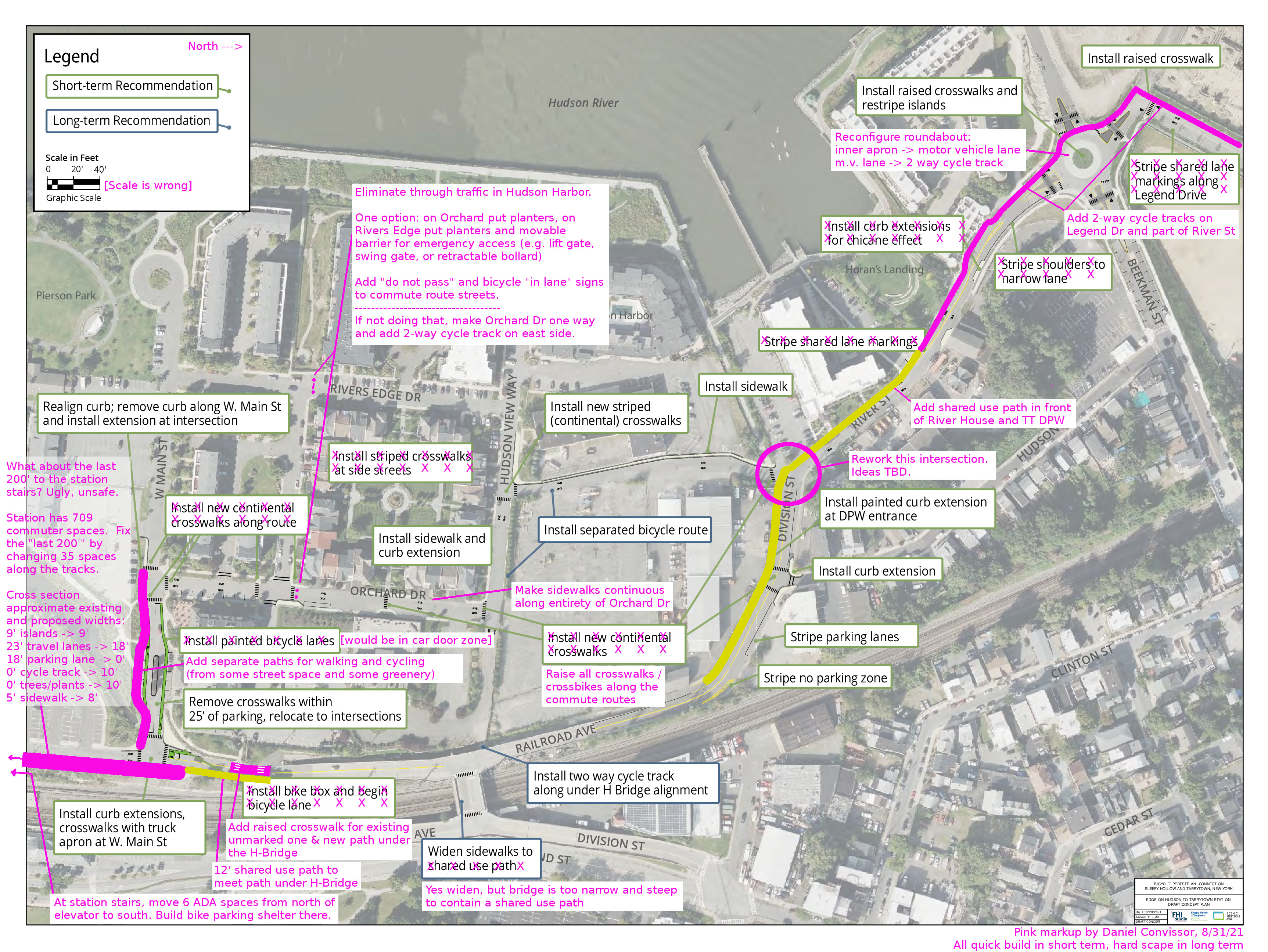
Here is a map outlining all of these suggestions. (Click it for higher resolution.)
Here are plans for how to quickly complete RiverWalk in Sleepy Hollow.
biketarrytown.org | info@biketarrytown.org | B: @biketarrytown.bsky.social | F: @BikeTarrytn